Passwort verloren? Neuer Benutzer? Registrieren
Big eye, Philippines. Photo by Stephane Rochon.
Genieße und Trage etwas bei!
| Finde den besten Tauchplatz |
|
|
 Dirt Island
USA, Oregon
Dies ist eine interaktive Karte! Verwende die Steuerelemente zum schwenken und zoomen.
|
Datum: WGS84 [ Hilfe ] |
Breitengrad: 44° 4.899' N |
Benutzer Bewertung (0)
- Favorit
-
Deine Favoriten und zukünftigen Tauchplatzlisten
Zugang
|
English (Übersetze diesen text in Deutsch): Head east on Hwy 126, turn right at Cougar Dam Rd/Natl Forest Develop Road 19 Rd, Slight right at Aufderheide Dr go about 3 miles , Slight right to stay on Aufderheide Dr go about 100 ft., Turn right to stay on Aufderheide Dr go 6.3 miles, Turn left at Natl Forest Develop Road 500 Rd go 1.1 miles, Continue until you find south boat ramp. Wie? Mit dem Boot Entfernung Kurze Bootszeit (< 10min) Leicht zu finden? Leicht zu finden |
Tauchplatz Merkmale
Durchschnittstiefe 12.2 m / 40 ft
max. Tiefe 39.6 m / 129.9 ft
Strömung Niedrig ( < 1 Knoten)
Sichtweite Schlecht
Qualität
Tauchplatz Qualität Standard
Erfahrung CMAS ** / AOW
Biointeresse Mager
Mehr Details
Wochenaufkommen
Wochenendaufkommen
Art des Tauchgangs
- Frischwasser
- Wand
- Tief
Tauchplatz Aktivitäten
Gefahren
- Tiefe
- Bootsverkehr
Zusätzliche Informationen
English (Übersetze diesen text in Deutsch): The west side of the island declines to 40 feet, then a wall down to 130 and a flat landing at 130. The visibility can vary due to small current and dirt. This is an advanced dive.
Verfasser: Scubastu01 Mitarbeiter (1) Sie tauchten den Tauchplatz! (1)
 Fotos
Fotos
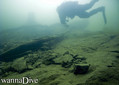
Dirt Island |
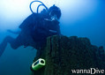
Dirt Island |
Kommentare
Sei der erste der einen Kommentar über dieses Land schreibt
Errors, Feedback
Du kannst diese Seite ändern um Fehler zu beheben oder neue Information hinzuzufügen. Wenn du Probleme mit der Seite hast, Schicken Sie uns Ihr Feedback.
Bewerbe
Wannadive.net 24/24
Wannadive.net auf deinem Handy
![]()
RSS Alle RSS-Feeds von Wannadive.net
Newsletter Alle News per Email