|
English (Übersetze diesen text in Deutsch): Spruce Creek Trail to Pacific Tarn Lake
From the last traffic light on South Main Street in Breckenridge drive south on Highway 9 for about 2.3 miles to Spruce Creek Road. Turn right onto Spruce Creek Road and drive 1.2 miles to the well marked Spruce Creek Trailhead 10,380 ft. This is a good place to park passenger cars. From here the road gets rougher, but 4wd and high clearance vehicles will do fine and can continue for another approximately 2 miles until it ends at 11,100 ft. This is the upper Spruce Creek Trailhead.
Start hiking and shortly, you will find a trail intersection for Mayflower Lake to the right and Mohawk Lakes and Continental Falls to the left. Go left toward Mohawk Lakes. The trail twists steeply by a mining cabin to a marked split for Lower Continental Falls. It follows a useful mining cable past the falls split up open rock, moderating to the edge of Lower Mohawk Lake.
Once above the falls, the main trail heads for an old mining apparatus that looks like a ski lift. Go right past this mining apparatus and continue on the trail. If you made it this far, then you are on the right trail, and staying on it now is much easier.
The trail goes skirts Lower Mohawk Lake on its south side, and then takes a hard left turn south. The trail now is taking the long way around the cliffs and waterfalls below Mohawk Lake.
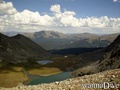
After Mohawk Lake the trail immediately begins to veer away from the lake to the north, and will take you past Upper Mohawk Lake #1 on the lake’s north side and continues across relatively flat open tundra to the Upper Mohawk Lakes #2 and #3. Cross this lake on its north side by rock-hopping across the exit of the lake. Skirt the lake and proceed directly toward the slope that is now directly ahead.
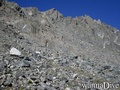
From here it requires a steep and demanding rock climbing to Pacific Tarn Lake.
English (Übersetze diesen text in Deutsch): Spruce Creek Trail to Pacific Tarn Lake
From the last traffic light on South Main Street in Breckenridge drive south on Highway 9 for about 2.3 miles to Spruce Creek Road. Turn right onto Spruce Creek Road and drive 1.2 miles to the well marked Spruce Creek Trailhead 10,380 ft. This is a good place to park passenger cars. From here the road gets rougher, but 4wd and high clearance vehicles will do fine and can continue for another approximately 2 miles until it ends at 11,100 ft. This is the upper Spruce Creek Trailhead.
Start hiking and shortly, you will find a trail intersection for Mayflower Lake to the right and Mohawk Lakes and Continental Falls to the left. Go left toward Mohawk Lakes. The trail twists steeply by a mining cabin to a marked split for Lower Continental Falls. It follows a useful mining cable past the falls split up open rock, moderating to the edge of Lower Mohawk Lake.
Once above the falls, the main trail heads for an old mining apparatus that looks like a ski lift. Go right past this mining apparatus and continue on the trail. If you made it this far, then you are on the right trail, and staying on it now is much easier.
The trail goes skirts Lower Mohawk Lake on its south side, and then takes a hard left turn south. The trail now is taking the long way around the cliffs and waterfalls below Mohawk Lake.
After Mohawk Lake the trail immediately begins to veer away from the lake to the north, and will take you past Upper Mohawk Lake #1 on the lake’s north side and continues across relatively flat open tundra to the Upper Mohawk Lakes #2 and #3. Cross this lake on its north side by rock-hopping across the exit of the lake. Skirt the lake and proceed directly toward the slope that is now directly ahead.
From here it requires a steep and demanding rock climbing to Pacific Tarn Lake.
Spruce Creek Trail to Pacific Tarn Lake
From the last traffic light on South Main Street in Breckenridge drive south on Highway 9 for about 2.3 miles to Spruce Creek Road. Turn right onto Spruce Creek Road and drive 1.2 miles to the well marked Spruce Creek Trailhead 10,380 ft. This is a good place to park passenger cars. From here the road gets rougher, but 4wd and high clearance vehicles will do fine and can continue for another approximately 2 miles until it ends at 11,100 ft. This is the upper Spruce Creek Trailhead.
Start hiking and shortly, you will find a trail intersection for Mayflower Lake to the right and Mohawk Lakes and Continental Falls to the left. Go left toward Mohawk Lakes. The trail twists steeply by a mining cabin to a marked split for Lower Continental Falls. It follows a useful mining cable past the falls split up open rock, moderating to the edge of Lower Mohawk Lake.
Once above the falls, the main trail heads for an old mining apparatus that looks like a ski lift. Go right past this mining apparatus and continue on the trail. If you made it this far, then you are on the right trail, and staying on it now is much easier.
The trail goes skirts Lower Mohawk Lake on its south side, and then takes a hard left turn south. The trail now is taking the long way around the cliffs and waterfalls below Mohawk Lake.
After Mohawk Lake the trail immediately begins to veer away from the lake to the north, and will take you past Upper Mohawk Lake #1 on the lake’s north side and continues across relatively flat open tundra to the Upper Mohawk Lakes #2 and #3. Cross this lake on its north side by rock-hopping across the exit of the lake. Skirt the lake and proceed directly toward the slope that is now directly ahead.
From here it requires a steep and demanding rock climbing to Pacific Tarn Lake.
English (Übersetze diesen text in Deutsch): Spruce Creek Trail to Pacific Tarn Lake
From the last traffic light on South Main Street in Breckenridge drive south on Highway 9 for about 2.3 miles to Spruce Creek Road. Turn right onto Spruce Creek Road and drive 1.2 miles to the well marked Spruce Creek Trailhead 10,380 ft. This is a good place to park passenger cars. From here the road gets rougher, but 4wd and high clearance vehicles will do fine and can continue for another approximately 2 miles until it ends at 11,100 ft. This is the upper Spruce Creek Trailhead.
Start hiking and shortly, you will find a trail intersection for Mayflower Lake to the right and Mohawk Lakes and Continental Falls to the left. Go left toward Mohawk Lakes. The trail twists steeply by a mining cabin to a marked split for Lower Continental Falls. It follows a useful mining cable past the falls split up open rock, moderating to the edge of Lower Mohawk Lake.
Once above the falls, the main trail heads for an old mining apparatus that looks like a ski lift. Go right past this mining apparatus and continue on the trail. If you made it this far, then you are on the right trail, and staying on it now is much easier.
The trail goes skirts Lower Mohawk Lake on its south side, and then takes a hard left turn south. The trail now is taking the long way around the cliffs and waterfalls below Mohawk Lake.
After Mohawk Lake the trail immediately begins to veer away from the lake to the north, and will take you past Upper Mohawk Lake #1 on the lake’s north side and continues across relatively flat open tundra to the Upper Mohawk Lakes #2 and #3. Cross this lake on its north side by rock-hopping across the exit of the lake. Skirt the lake and proceed directly toward the slope that is now directly ahead.
From here it requires a steep and demanding rock climbing to Pacific Tarn Lake.
Wie? Vom Ufer
Entfernung
Leicht zu finden? Schwer zu finden
|
|
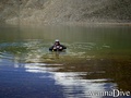
 Pacific Tarn lake
 Fotos
Fotos