Dies ist eine interaktive Karte! Verwende die Steuerelemente zum schwenken und zoomen.
Zugang
|
English (Übersetze diesen text in Deutsch): Proceed nothwest from Regina, Saskatchewan on highway #11 to Chamberlain. From Chamberlain proceed south 1.7 km to a grid road where you will turn right and drive 4.0 km. Finally turn right again for .8 km and you are there.
The dive access point is .3 km to the west.
Proceed nothwest from Regina, Saskatchewan on highway #11 to Chamberlain. From Chamberlain proceed south 1.7 km to a grid road where you will turn right and drive 4.0 km. Finally turn right again for .8 km and you are there.
The dive access point is .3 km to the west.
English (Übersetze diesen text in Deutsch): Proceed nothwest from Regina, Saskatchewan on highway #11 to Chamberlain. From Chamberlain proceed south 1.7 km to a grid road where you will turn right and drive 4.0 km. Finally turn right again for .8 km and you are there.
The dive access point is .3 km to the west.
Wie? Vom Ufer
Entfernung Sofortiger Zugang
Leicht zu finden? Leicht zu finden
|
|
Tauchplatz Merkmale
Alternativer Name Lovering Lake
Durchschnittstiefe 7.6 m / 24.9 ft
max. Tiefe 15.8 m / 51.8 ft
Strömung Keine
Sichtweite Schlecht
Qualität
Tauchplatz Qualität Warum nicht
Erfahrung Alle Taucher
Biointeresse Mager
Mehr Details
Wochenaufkommen
Wochenendaufkommen
Art des Tauchgangs
- Frischwasser
- Eis
Tauchplatz Aktivitäten
- Nachttauchen
- Tauchtraining
Gefahren
Zusätzliche Informationen
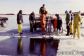
English (Übersetze diesen text in Deutsch): Lovering Lake is considered a training lake, with open water checkouts occurring there almost every spring to fall weekend. Visibilty is best in the early spring and again in the late fall. Ice diving visibility can be as high as 60-75 feet.
Towards the west end of the lake there is no vegetation.
In this area, divers have created a submerged diving platform off the silt/mud bottom with a "telephone booth", and a compass course to challenge all levels of divers.
Lovering Lake is considered a training lake, with open water checkouts occurring there almost every spring to fall weekend. Visibilty is best in the early spring and again in the late fall. Ice diving visibility can be as high as 60-75 feet.
Towards the west end of the lake there is no vegetation.
In this area, divers have created a submerged diving platform off the silt/mud bottom with a "telephone booth", and a compass course to challenge all levels of divers.
English (Übersetze diesen text in Deutsch): Lovering Lake is considered a training lake, with open water checkouts occurring there almost every spring to fall weekend. Visibilty is best in the early spring and again in the late fall. Ice diving visibility can be as high as 60-75 feet.
Towards the west end of the lake there is no vegetation.
In this area, divers have created a submerged diving platform off the silt/mud bottom with a "telephone booth", and a compass course to challenge all levels of divers.
 Kommentare
Zeige alle (0)...
Sei der erste der einen Kommentar über dieses Land schreibt
Errors, Feedback
Du kannst diese Seite ändern um Fehler zu beheben oder neue Information hinzuzufügen. Wenn du Probleme mit der Seite hast, Schicken Sie uns Ihr Feedback.
Wannadive.net 24/24
Wannadive.net auf deinem Handy

Newsletter Alle News per Email
 Lovering Lakes