Dies ist eine interaktive Karte! Verwende die Steuerelemente zum schwenken und zoomen.
Zugang
|
English (Übersetze diesen text in Deutsch): Princess Lodge is a shallow dive site with parking down a steep drive very close to the water. It is along the west side of the Bedford Basin, and must be accessed from driving north along the Bedford Highway, as the steep driveway is just a small break in the guardrail. The drive is rough so go slowly, and watch for trains, which cross the drive, but do so slowly around 20 km/hr as it is in town.
Three of four vehicles at most can fit. It is a park, so we usually only dive here shoulder seasons. In winter, the driveway down isn't plowed, so check before taking a group there.
Princess Lodge is a shallow dive site with parking down a steep drive very close to the water. It is along the west side of the Bedford Basin, and must be accessed from driving north along the Bedford Highway, as the steep driveway is just a small break in the guardrail. The drive is rough so go slowly, and watch for trains, which cross the drive, but do so slowly around 20 km/hr as it is in town.
Three of four vehicles at most can fit. It is a park, so we usually only dive here shoulder seasons. In winter, the driveway down isn't plowed, so check before taking a group there.
English (Übersetze diesen text in Deutsch): Princess Lodge is a shallow dive site with parking down a steep drive very close to the water. It is along the west side of the Bedford Basin, and must be accessed from driving north along the Bedford Highway, as the steep driveway is just a small break in the guardrail. The drive is rough so go slowly, and watch for trains, which cross the drive, but do so slowly around 20 km/hr as it is in town.
Three of four vehicles at most can fit. It is a park, so we usually only dive here shoulder seasons. In winter, the driveway down isn't plowed, so check before taking a group there.
Wie? Vom Ufer
Entfernung Sofortiger Zugang
Leicht zu finden? Leicht zu finden
|
|
Tauchplatz Merkmale
Durchschnittstiefe 13.7 m / 44.9 ft
max. Tiefe 6.1 m / 20 ft
Strömung Keine
Sichtweite Mittel ( 5 - 10 m)
Qualität
Tauchplatz Qualität Gut
Erfahrung Alle Taucher
Biointeresse Interessant
Mehr Details
Wochenaufkommen
Wochenendaufkommen
Art des Tauchgangs
- Ambiente
- Seicht
Tauchplatz Aktivitäten
- Meeresbiologie
- Nachttauchen
- Tauchtraining
- Photography
Gefahren
Zusätzliche Informationen
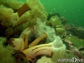
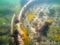
English (Übersetze diesen text in Deutsch): The dive site is shallow gradually sloping out from the shore to the east. There are piles of shal rocks forming ridges and mounds with rich marine life on them - sea anemones, sponges, coraline algae, barnacles and other marine life. The bottom is soft with numerous stalked sea anemones. The area has been a dumping ground and spot for vessel strandings in the past, so there is industrial debris scattered about - old cable, pipes, steam ship remains, making for some interesting exploring.
English (Übersetze diesen text in Deutsch): The dive site is shallow gradually sloping out from the shore to the east. There are piles of shal rocks forming ridges and mounds with rich marine life on them - sea anemones, sponges, coraline algae, barnacles and other marine life. The bottom is soft with numerous stalked sea anemones. The area has been a dumping ground and spot for vessel strandings in the past, so there is industrial debris scattered about - old cable, pipes, steam ship remains, making for some interesting exploring.
The dive site is shallow gradually sloping out from the shore to the east. There are piles of shal rocks forming ridges and mounds with rich marine life on them - sea anemones, sponges, coraline algae, barnacles and other marine life. The bottom is soft with numerous stalked sea anemones. The area has been a dumping ground and spot for vessel strandings in the past, so there is industrial debris scattered about - old cable, pipes, steam ship remains, making for some interesting exploring.
English (Übersetze diesen text in Deutsch): The dive site is shallow gradually sloping out from the shore to the east. There are piles of shal rocks forming ridges and mounds with rich marine life on them - sea anemones, sponges, coraline algae, barnacles and other marine life. The bottom is soft with numerous stalked sea anemones. The area has been a dumping ground and spot for vessel strandings in the past, so there is industrial debris scattered about - old cable, pipes, steam ship remains, making for some interesting exploring.
English (Übersetze diesen text in Deutsch): The dive site is shallow gradually sloping out from the shore to the east. There are piles of shal rocks forming ridges and mounds with rich marine life on them - sea anemones, sponges, coraline algae, barnacles and other marine life. The bottom is soft with numerous stalked sea anemones. The area has been a dumping ground and spot for vessel strandings in the past, so there is industrial debris scattered about - old cable, pipes, steam ship remains, making for some interesting exploring.
English (Übersetze diesen text in Deutsch): The dive site is shallow gradually sloping out from the shore to the east. There are piles of shal rocks forming ridges and mounds with rich marine life on them - sea anemones, sponges, coraline algae, barnacles and other marine life. The bottom is soft with numerous stalked sea anemones. The area has been a dumping ground and spot for vessel strandings in the past, so there is industrial debris scattered about - old cable, pipes, steam ship remains, making for some interesting exploring.
English (Übersetze diesen text in Deutsch): The dive site is shallow gradually sloping out from the shore to the east. There are piles of shal rocks forming ridges and mounds with rich marine life on them - sea anemones, sponges, coraline algae, barnacles and other marine life. The bottom is soft with numerous stalked sea anemones. The area has been a dumping ground and spot for vessel strandings in the past, so there is industrial debris scattered about - old cable, pipes, steam ship remains, making for some interesting exploring.
English (Übersetze diesen text in Deutsch): The dive site is shallow gradually sloping out from the shore to the east. There are piles of shal rocks forming ridges and mounds with rich marine life on them - sea anemones, sponges, coraline algae, barnacles and other marine life. The bottom is soft with numerous stalked sea anemones. The area has been a dumping ground and spot for vessel strandings in the past, so there is industrial debris scattered about - old cable, pipes, steam ship remains, making for some interesting exploring.
English (Übersetze diesen text in Deutsch): The dive site is shallow gradually sloping out from the shore to the east. There are piles of shal rocks forming ridges and mounds with rich marine life on them - sea anemones, sponges, coraline algae, barnacles and other marine life. The bottom is soft with numerous stalked sea anemones. The area has been a dumping ground and spot for vessel strandings in the past, so there is industrial debris scattered about - old cable, pipes, steam ship remains, making for some interesting exploring.
 Kommentare
Zeige alle (0)...
Sei der erste der einen Kommentar über dieses Land schreibt
Errors, Feedback
Du kannst diese Seite ändern um Fehler zu beheben oder neue Information hinzuzufügen. Wenn du Probleme mit der Seite hast, Schicken Sie uns Ihr Feedback.
 Princess Lodge