Dies ist eine interaktive Karte! Verwende die Steuerelemente zum schwenken und zoomen.
Zugang
|
English (Übersetze diesen text in Deutsch): Access from route 655 from øye in too the mountain
English (Übersetze diesen text in Deutsch): Access from route 655 from øye in too the mountain
Access from route 655 from øye in too the mountain
English (Übersetze diesen text in Deutsch): Access from route 655 from øye in too the mountain
English (Übersetze diesen text in Deutsch): Access from route 655 from øye in too the mountain
English (Übersetze diesen text in Deutsch): Access from route 655 from øye in too the mountain
English (Übersetze diesen text in Deutsch): Access from route 655 from øye in too the mountain
English (Übersetze diesen text in Deutsch): Access from route 655 from øye in too the mountain
English (Übersetze diesen text in Deutsch): Access from route 655 from øye in too the mountain
Wie? Vom Ufer
Entfernung Sofortiger Zugang
Leicht zu finden? Leicht zu finden
|
|
Tauchplatz Merkmale
Alternativer Name Civilizatione lost
Durchschnittstiefe 10 m / 32.8 ft
max. Tiefe 18 m / 59.1 ft
Strömung Keine
Sichtweite Gut ( 10 - 30 m)
Qualität
Tauchplatz Qualität Großartig
Erfahrung CMAS * / OW
Biointeresse Kein
Mehr Details
Wochenaufkommen
Wochenendaufkommen
Art des Tauchgangs
- Frischwasser
Tauchplatz Aktivitäten
- Nachttauchen
- Schnorcheln / Freitauchen
- Photography
- Behindertengerechtes Tauchen
Gefahren
Zusätzliche Informationen
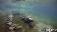
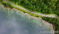
English (Übersetze diesen text in Deutsch): A small village that was flooded after a rock slide that blocked the river that flows down the valley and formed an artificial lake and flooded a farm that still stands as one can see today
The lake is at an altitude of ca 200 meter's above sea level
English (Übersetze diesen text in Deutsch): A small village that was flooded after a rock slide that blocked the river that flows down the valley and formed an artificial lake and flooded a farm that still stands as one can see today
The lake is at an altitude of ca 200 meter's above sea level
A small village that was flooded after a rock slide that blocked the river that flows down the valley and formed an artificial lake and flooded a farm that still stands as one can see today
The lake is at an altitude of ca 200 meter's above sea level
English (Übersetze diesen text in Deutsch): A small village that was flooded after a rock slide that blocked the river that flows down the valley and formed an artificial lake and flooded a farm that still stands as one can see today
The lake is at an altitude of ca 200 meter's above sea level
English (Übersetze diesen text in Deutsch): A small village that was flooded after a rock slide that blocked the river that flows down the valley and formed an artificial lake and flooded a farm that still stands as one can see today
The lake is at an altitude of ca 200 meter's above sea level
English (Übersetze diesen text in Deutsch): A small village that was flooded after a rock slide that blocked the river that flows down the valley and formed an artificial lake and flooded a farm that still stands as one can see today
The lake is at an altitude of ca 200 meter's above sea level
English (Übersetze diesen text in Deutsch): A small village that was flooded after a rock slide that blocked the river that flows down the valley and formed an artificial lake and flooded a farm that still stands as one can see today
The lake is at an altitude of ca 200 meter's above sea level
English (Übersetze diesen text in Deutsch): A small village that was flooded after a rock slide that blocked the river that flows down the valley and formed an artificial lake and flooded a farm that still stands as one can see today
The lake is at an altitude of ca 200 meter's above sea level
English (Übersetze diesen text in Deutsch): A small village that was flooded after a rock slide that blocked the river that flows down the valley and formed an artificial lake and flooded a farm that still stands as one can see today
The lake is at an altitude of ca 200 meter's above sea level
 Kommentare
Zeige alle (0)...
Sei der erste der einen Kommentar über dieses Land schreibt
Errors, Feedback
Du kannst diese Seite ändern um Fehler zu beheben oder neue Information hinzuzufügen. Wenn du Probleme mit der Seite hast, Schicken Sie uns Ihr Feedback.
Wannadive.net 24/24
Wannadive.net auf deinem Handy

Newsletter Alle News per Email
 Lyngstølsvatnet