Dies ist eine interaktive Karte! Verwende die Steuerelemente zum schwenken und zoomen.
Zugang
|
English (Übersetze diesen text in Deutsch): The impressive wreck of Tihany lays in the entrance of the Bay of Kotor, next to the island Mamula. The Austro-Hungarian Sea Steamship was built in Trieste in 1908 with a length of 45.40 metres, depth 3.04 metres, width 5.75 metres and a gross displacement of 204 tonnes. It had two masts to support its sails; with the aid of the wind and the 425BHP triplex steam-engine Tihany could reach speeds up to12 knots.
6th Nov 2010 Wreck position is: 42° 23.997' North, 18° 33.459'East. This is about 430m to the North of Mamula Island.
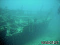
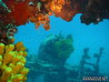
The impressive wreck of Tihany lays in the entrance of the Bay of Kotor, next to the island Mamula. The Austro-Hungarian Sea Steamship was built in Trieste in 1908 with a length of 45.40 metres, depth 3.04 metres, width 5.75 metres and a gross displacement of 204 tonnes. It had two masts to support its sails; with the aid of the wind and the 425BHP triplex steam-engine Tihany could reach speeds up to12 knots.
6th Nov 2010 Wreck position is: 42° 23.997' North, 18° 33.459'East. This is about 430m to the North of Mamula Island.
English (Übersetze diesen text in Deutsch): The impressive wreck of Tihany lays in the entrance of the Bay of Kotor, next to the island Mamula. The Austro-Hungarian Sea Steamship was built in Trieste in 1908 with a length of 45.40 metres, depth 3.04 metres, width 5.75 metres and a gross displacement of 204 tonnes. It had two masts to support its sails; with the aid of the wind and the 425BHP triplex steam-engine Tihany could reach speeds up to12 knots.
6th Nov 2010 Wreck position is: 42° 23.997' North, 18° 33.459'East. This is about 430m to the North of Mamula Island.
Wie? Mit dem Boot
Entfernung Gute Bootszeit (< 30min)
Leicht zu finden? Schwer zu finden
|
|
Tauchplatz Merkmale
Alternativer Name Wreck of Tihany
Durchschnittstiefe 34 m / 111.5 ft
max. Tiefe 42 m / 137.8 ft
Strömung Keine
Sichtweite Gut ( 10 - 30 m)
Qualität
Tauchplatz Qualität Standard
Erfahrung CMAS ** / AOW
Biointeresse Interessant
Mehr Details
Wochenaufkommen
Wochenendaufkommen
Art des Tauchgangs
- Wrack
Tauchplatz Aktivitäten
- Photography
Gefahren
- Tiefe
Zusätzliche Informationen
English (Übersetze diesen text in Deutsch): On the 12th of February, 1917 Tihany was carrying 129 tonnes of coal and a tank wagon of oil from Kotor to Bar, when navigation difficulties due to the sea mines in the area led to the ship running into Cape Arsa. Efforts were made to tow the ship, but the hull was severely damaged, and Tihany found its watery grave 40 metres under the surface.
The bell recovered from the wreck by our team in 2004 undeniably confirmed the tragedy of Tihany.
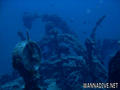
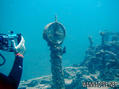
On the 12th of February, 1917 Tihany was carrying 129 tonnes of coal and a tank wagon of oil from Kotor to Bar, when navigation difficulties due to the sea mines in the area led to the ship running into Cape Arsa. Efforts were made to tow the ship, but the hull was severely damaged, and Tihany found its watery grave 40 metres under the surface.
The bell recovered from the wreck by our team in 2004 undeniably confirmed the tragedy of Tihany.
English (Übersetze diesen text in Deutsch): On the 12th of February, 1917 Tihany was carrying 129 tonnes of coal and a tank wagon of oil from Kotor to Bar, when navigation difficulties due to the sea mines in the area led to the ship running into Cape Arsa. Efforts were made to tow the ship, but the hull was severely damaged, and Tihany found its watery grave 40 metres under the surface.
The bell recovered from the wreck by our team in 2004 undeniably confirmed the tragedy of Tihany.
 Kommentare
Zeige alle (0)...
Sei der erste der einen Kommentar über dieses Land schreibt
Errors, Feedback
Du kannst diese Seite ändern um Fehler zu beheben oder neue Information hinzuzufügen. Wenn du Probleme mit der Seite hast, Schicken Sie uns Ihr Feedback.
Wannadive.net 24/24
Wannadive.net auf deinem Handy

Newsletter Alle News per Email
 Tihany