Passwort verloren? Neuer Benutzer? Registrieren
Big eye, Philippines. Photo by Stephane Rochon.
Genieße und Trage etwas bei!
| Finde den besten Tauchplatz |
|
|
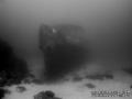
 Imperial Eagle MV
Malta, Malta island
Dies ist eine interaktive Karte! Verwende die Steuerelemente zum schwenken und zoomen.
|
Datum: WGS84 [ Hilfe ] |
Breitengrad: 35° 57.096' N |
Benutzer Bewertung (1)
- Favorit
-
Deine Favoriten und zukünftigen Tauchplatzlisten
Zugang
|
Wie? Mit dem Boot Entfernung Gute Bootszeit (< 30min) Leicht zu finden? Leicht zu finden |
Tauchplatz Merkmale
Alternativer Name Imperial Eagle ferry
Durchschnittstiefe 35 m / 114.8 ft
max. Tiefe 46 m / 150.9 ft
Strömung Niedrig ( < 1 Knoten)
Sichtweite Gut ( 10 - 30 m)
Qualität
Tauchplatz Qualität Großartig
Erfahrung CMAS ** / AOW
Biointeresse Interessant
Mehr Details
Wochenaufkommen
Wochenendaufkommen
Art des Tauchgangs
- Wrack
Tauchplatz Aktivitäten
- Tauchtraining
- Photography
Gefahren
- Tiefe
Zusätzliche Informationen
English (Übersetze diesen text in Deutsch): The Imperial Eagle was one of the ferryboats connecting Malta and Gozo.
The hull, in navigation trim, lays on a sandy bottom at a depth of -42m, 300m North-East of Qwara Point.
Verfasser: Vladimir Dunaev Mitarbeiter (1) Sie tauchten den Tauchplatz! (6)
 Fotos
Fotos

Imperial Eagle MV |

Imperial Eagle MV |

Imperial Eagle MV |
Imperial Eagle MV |
Kommentare
Sei der erste der einen Kommentar über dieses Land schreibt
Errors, Feedback
Du kannst diese Seite ändern um Fehler zu beheben oder neue Information hinzuzufügen. Wenn du Probleme mit der Seite hast, Schicken Sie uns Ihr Feedback.
Bewerbe
Wannadive.net 24/24
Wannadive.net auf deinem Handy
![]()
RSS Alle RSS-Feeds von Wannadive.net
Newsletter Alle News per Email