Dies ist eine interaktive Karte! Verwende die Steuerelemente zum schwenken und zoomen.
Zugang
|
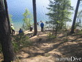
Wie? Vom Ufer
Entfernung Sofortiger Zugang
Leicht zu finden? Leicht zu finden
|
|
Tauchplatz Merkmale
Durchschnittstiefe 7 m / 23 ft
max. Tiefe 12 m / 39.4 ft
Strömung Keine
Sichtweite Mittel ( 5 - 10 m)
Qualität
Tauchplatz Qualität Gut
Erfahrung Alle Taucher
Biointeresse Interessant
Mehr Details
Wochenaufkommen
Wochenendaufkommen
Art des Tauchgangs
- Frischwasser
Tauchplatz Aktivitäten
- Meeresbiologie
- Kinder tauchen
- Nachttauchen
- Erster Tauchgang
- Tauchtraining
- Schnorcheln / Freitauchen
- Orientierung
- Photography
Gefahren
Zusätzliche Informationen
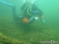
English (Übersetze diesen text in Deutsch): From the entrance zone, following 210 the stone formation can be reached after about 100m on 7m deep. Till the stones max depth is about 12m. On the left side of the entrance after few meters on max dept 2m there is a underwater grass field that usually have pentry of fishes. Going straight towards middle of the lake, the depth can reach over 20m but there is only mud, cold and darkness.
English (Übersetze diesen text in Deutsch): From the entrance zone, following 210 the stone formation can be reached after about 100m on 7m deep. Till the stones max depth is about 12m. On the left side of the entrance after few meters on max dept 2m there is a underwater grass field that usually have pentry of fishes. Going straight towards middle of the lake, the depth can reach over 20m but there is only mud, cold and darkness.
From the entrance zone, following 210 the stone formation can be reached after about 100m on 7m deep. Till the stones max depth is about 12m. On the left side of the entrance after few meters on max dept 2m there is a underwater grass field that usually have pentry of fishes. Going straight towards middle of the lake, the depth can reach over 20m but there is only mud, cold and darkness.
English (Übersetze diesen text in Deutsch): From the entrance zone, following 210 the stone formation can be reached after about 100m on 7m deep. Till the stones max depth is about 12m. On the left side of the entrance after few meters on max dept 2m there is a underwater grass field that usually have pentry of fishes. Going straight towards middle of the lake, the depth can reach over 20m but there is only mud, cold and darkness.
English (Übersetze diesen text in Deutsch): From the entrance zone, following 210 the stone formation can be reached after about 100m on 7m deep. Till the stones max depth is about 12m. On the left side of the entrance after few meters on max dept 2m there is a underwater grass field that usually have pentry of fishes. Going straight towards middle of the lake, the depth can reach over 20m but there is only mud, cold and darkness.
English (Übersetze diesen text in Deutsch): From the entrance zone, following 210 the stone formation can be reached after about 100m on 7m deep. Till the stones max depth is about 12m. On the left side of the entrance after few meters on max dept 2m there is a underwater grass field that usually have pentry of fishes. Going straight towards middle of the lake, the depth can reach over 20m but there is only mud, cold and darkness.
English (Übersetze diesen text in Deutsch): From the entrance zone, following 210 the stone formation can be reached after about 100m on 7m deep. Till the stones max depth is about 12m. On the left side of the entrance after few meters on max dept 2m there is a underwater grass field that usually have pentry of fishes. Going straight towards middle of the lake, the depth can reach over 20m but there is only mud, cold and darkness.
English (Übersetze diesen text in Deutsch): From the entrance zone, following 210 the stone formation can be reached after about 100m on 7m deep. Till the stones max depth is about 12m. On the left side of the entrance after few meters on max dept 2m there is a underwater grass field that usually have pentry of fishes. Going straight towards middle of the lake, the depth can reach over 20m but there is only mud, cold and darkness.
English (Übersetze diesen text in Deutsch): From the entrance zone, following 210 the stone formation can be reached after about 100m on 7m deep. Till the stones max depth is about 12m. On the left side of the entrance after few meters on max dept 2m there is a underwater grass field that usually have pentry of fishes. Going straight towards middle of the lake, the depth can reach over 20m but there is only mud, cold and darkness.
 Kommentare
Zeige alle (0)...
Sei der erste der einen Kommentar über dieses Land schreibt
Errors, Feedback
Du kannst diese Seite ändern um Fehler zu beheben oder neue Information hinzuzufügen. Wenn du Probleme mit der Seite hast, Schicken Sie uns Ihr Feedback.
Wannadive.net 24/24
Wannadive.net auf deinem Handy

Newsletter Alle News per Email
 Iso-Melkutin