Dies ist eine interaktive Karte! Verwende die Steuerelemente zum schwenken und zoomen.
Zugang
|
English (Übersetze diesen text in Deutsch): Saranda bay
English (Übersetze diesen text in Deutsch): Saranda bay
Saranda bay
English (Übersetze diesen text in Deutsch): Saranda bay
English (Übersetze diesen text in Deutsch): Saranda bay
English (Übersetze diesen text in Deutsch): Saranda bay
English (Übersetze diesen text in Deutsch): Saranda bay
English (Übersetze diesen text in Deutsch): Saranda bay
English (Übersetze diesen text in Deutsch): Saranda bay
Wie?
Entfernung
Leicht zu finden?
|
|
Tauchplatz Merkmale
Durchschnittstiefe 15 m / 49.2 ft
max. Tiefe 30 m / 98.4 ft
Strömung
Sichtweite
Qualität
Tauchplatz Qualität
Erfahrung
Biointeresse
Mehr Details
Wochenaufkommen
Wochenendaufkommen
Art des Tauchgangs
Tauchplatz Aktivitäten
Gefahren
Zusätzliche Informationen
English (Übersetze diesen text in Deutsch): Inside the Bay of Saranda there lies an Italian cargoship. It was sunk during the II World War by German Bombers on their way back from an attack on the Balkans. Traces of the bombs can still be seen on the ships sides! The vessel lies on its port side on the sandy bed at a maximum depth of 18m just 300m away from the shore. At the shallowest point the ship is just 3m form the surface and is marked with a bouy. The ship is roughly 115m long. It is marked above water by a Cardinal bouy signalling danger. Visibility underwater is good about 20m.
English (Übersetze diesen text in Deutsch): Inside the Bay of Saranda there lies an Italian cargoship. It was sunk during the II World War by German Bombers on their way back from an attack on the Balkans. Traces of the bombs can still be seen on the ships sides! The vessel lies on its port side on the sandy bed at a maximum depth of 18m just 300m away from the shore. At the shallowest point the ship is just 3m form the surface and is marked with a bouy. The ship is roughly 115m long. It is marked above water by a Cardinal bouy signalling danger. Visibility underwater is good about 20m.
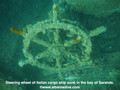
Inside the Bay of Saranda there lies an Italian cargoship. It was sunk during the II World War by German Bombers on their way back from an attack on the Balkans. Traces of the bombs can still be seen on the ships sides! The vessel lies on its port side on the sandy bed at a maximum depth of 18m just 300m away from the shore. At the shallowest point the ship is just 3m form the surface and is marked with a bouy. The ship is roughly 115m long. It is marked above water by a Cardinal bouy signalling danger. Visibility underwater is good about 20m.
English (Übersetze diesen text in Deutsch): Inside the Bay of Saranda there lies an Italian cargoship. It was sunk during the II World War by German Bombers on their way back from an attack on the Balkans. Traces of the bombs can still be seen on the ships sides! The vessel lies on its port side on the sandy bed at a maximum depth of 18m just 300m away from the shore. At the shallowest point the ship is just 3m form the surface and is marked with a bouy. The ship is roughly 115m long. It is marked above water by a Cardinal bouy signalling danger. Visibility underwater is good about 20m.
English (Übersetze diesen text in Deutsch): Inside the Bay of Saranda there lies an Italian cargoship. It was sunk during the II World War by German Bombers on their way back from an attack on the Balkans. Traces of the bombs can still be seen on the ships sides! The vessel lies on its port side on the sandy bed at a maximum depth of 18m just 300m away from the shore. At the shallowest point the ship is just 3m form the surface and is marked with a bouy. The ship is roughly 115m long. It is marked above water by a Cardinal bouy signalling danger. Visibility underwater is good about 20m.
English (Übersetze diesen text in Deutsch): Inside the Bay of Saranda there lies an Italian cargoship. It was sunk during the II World War by German Bombers on their way back from an attack on the Balkans. Traces of the bombs can still be seen on the ships sides! The vessel lies on its port side on the sandy bed at a maximum depth of 18m just 300m away from the shore. At the shallowest point the ship is just 3m form the surface and is marked with a bouy. The ship is roughly 115m long. It is marked above water by a Cardinal bouy signalling danger. Visibility underwater is good about 20m.
English (Übersetze diesen text in Deutsch): Inside the Bay of Saranda there lies an Italian cargoship. It was sunk during the II World War by German Bombers on their way back from an attack on the Balkans. Traces of the bombs can still be seen on the ships sides! The vessel lies on its port side on the sandy bed at a maximum depth of 18m just 300m away from the shore. At the shallowest point the ship is just 3m form the surface and is marked with a bouy. The ship is roughly 115m long. It is marked above water by a Cardinal bouy signalling danger. Visibility underwater is good about 20m.
English (Übersetze diesen text in Deutsch): Inside the Bay of Saranda there lies an Italian cargoship. It was sunk during the II World War by German Bombers on their way back from an attack on the Balkans. Traces of the bombs can still be seen on the ships sides! The vessel lies on its port side on the sandy bed at a maximum depth of 18m just 300m away from the shore. At the shallowest point the ship is just 3m form the surface and is marked with a bouy. The ship is roughly 115m long. It is marked above water by a Cardinal bouy signalling danger. Visibility underwater is good about 20m.
English (Übersetze diesen text in Deutsch): Inside the Bay of Saranda there lies an Italian cargoship. It was sunk during the II World War by German Bombers on their way back from an attack on the Balkans. Traces of the bombs can still be seen on the ships sides! The vessel lies on its port side on the sandy bed at a maximum depth of 18m just 300m away from the shore. At the shallowest point the ship is just 3m form the surface and is marked with a bouy. The ship is roughly 115m long. It is marked above water by a Cardinal bouy signalling danger. Visibility underwater is good about 20m.
 Kommentare
Zeige alle (0)...
Sei der erste der einen Kommentar über dieses Land schreibt
Errors, Feedback
Du kannst diese Seite ändern um Fehler zu beheben oder neue Information hinzuzufügen. Wenn du Probleme mit der Seite hast, Schicken Sie uns Ihr Feedback.
Wannadive.net 24/24
Wannadive.net auf deinem Handy

Newsletter Alle News per Email
 Italian Freighter Probitas