Dies ist eine interaktive Karte! Verwende die Steuerelemente zum schwenken und zoomen.
Zugang
|
English (Übersetze diesen text in Deutsch): Access is possible by boat only. The site is about a 2.2km ride from the harbour jetty. The wreck is in the harbour approaches, and there may be significant boat traffic
Use sonar &side scanner for locating wreck
English (Übersetze diesen text in Deutsch): Access is possible by boat only. The site is about a 2.2km ride from the harbour jetty. The wreck is in the harbour approaches, and there may be significant boat traffic
Use sonar &side scanner for locating wreck
Access is possible by boat only. The site is about a 2.2km ride from the harbour jetty. The wreck is in the harbour approaches, and there may be significant boat traffic
Use sonar &side scanner for locating wreck
English (Übersetze diesen text in Deutsch): Access is possible by boat only. The site is about a 2.2km ride from the harbour jetty. The wreck is in the harbour approaches, and there may be significant boat traffic
Use sonar &side scanner for locating wreck
English (Übersetze diesen text in Deutsch): Access is possible by boat only. The site is about a 2.2km ride from the harbour jetty. The wreck is in the harbour approaches, and there may be significant boat traffic
Use sonar &side scanner for locating wreck
English (Übersetze diesen text in Deutsch): Access is possible by boat only. The site is about a 2.2km ride from the harbour jetty. The wreck is in the harbour approaches, and there may be significant boat traffic
Use sonar &side scanner for locating wreck
English (Übersetze diesen text in Deutsch): Access is possible by boat only. The site is about a 2.2km ride from the harbour jetty. The wreck is in the harbour approaches, and there may be significant boat traffic
Use sonar &side scanner for locating wreck
English (Übersetze diesen text in Deutsch): Access is possible by boat only. The site is about a 2.2km ride from the harbour jetty. The wreck is in the harbour approaches, and there may be significant boat traffic
Use sonar &side scanner for locating wreck
English (Übersetze diesen text in Deutsch): Access is possible by boat only. The site is about a 2.2km ride from the harbour jetty. The wreck is in the harbour approaches, and there may be significant boat traffic
Use sonar &side scanner for locating wreck
Wie? Mit dem Boot
Entfernung Kurze Bootszeit (< 10min)
Leicht zu finden? Schwer zu finden
|
|
Tauchplatz Merkmale
Durchschnittstiefe 27 m / 88.6 ft
max. Tiefe 28 m / 91.9 ft
Strömung Mittel ( 1-2 Knoten)
Sichtweite Gut ( 10 - 30 m)
Qualität
Tauchplatz Qualität Gut
Erfahrung CMAS ** / AOW
Biointeresse Interessant
Mehr Details
Wochenaufkommen
Wochenendaufkommen
Art des Tauchgangs
- Wrack
Tauchplatz Aktivitäten
- Tauchtraining
- Orientierung
- Photography
Gefahren
- Strömung
- Bootsverkehr
Zusätzliche Informationen
English (Übersetze diesen text in Deutsch): Flat sand bottom at about 27m. The ship stands almost level imbedded in the bottom as if floating in sand. The bow points towards approximately 330° magnetic (northwest). Deep scouring at bow and stern, usually to about 28m maximum, depending on the tide. The vessel is is essentially intact and still looks much like when it was afloat. The hull is intact with a few holes cut in it, and the superstructure except for the wheelhouse, and tripod mast are also intact. There is a fairly large rectangular hatch just forward of the superstructure. The gunwale is at about 24m depth, and the boat is about 36m long. Top of the mast is at about 9m depth The Aster is marked on the charts at the same position as the Katsu Maru, but is about 30m to the northeast of the other wreck, and both can be visited on the same dive.
English (Übersetze diesen text in Deutsch): Flat sand bottom at about 27m. The ship stands almost level imbedded in the bottom as if floating in sand. The bow points towards approximately 330° magnetic (northwest). Deep scouring at bow and stern, usually to about 28m maximum, depending on the tide. The vessel is is essentially intact and still looks much like when it was afloat. The hull is intact with a few holes cut in it, and the superstructure except for the wheelhouse, and tripod mast are also intact. There is a fairly large rectangular hatch just forward of the superstructure. The gunwale is at about 24m depth, and the boat is about 36m long. Top of the mast is at about 9m depth The Aster is marked on the charts at the same position as the Katsu Maru, but is about 30m to the northeast of the other wreck, and both can be visited on the same dive.
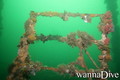
Flat sand bottom at about 27m. The ship stands almost level imbedded in the bottom as if floating in sand. The bow points towards approximately 330° magnetic (northwest). Deep scouring at bow and stern, usually to about 28m maximum, depending on the tide. The vessel is is essentially intact and still looks much like when it was afloat. The hull is intact with a few holes cut in it, and the superstructure except for the wheelhouse, and tripod mast are also intact. There is a fairly large rectangular hatch just forward of the superstructure. The gunwale is at about 24m depth, and the boat is about 36m long. Top of the mast is at about 9m depth The Aster is marked on the charts at the same position as the Katsu Maru, but is about 30m to the northeast of the other wreck, and both can be visited on the same dive.
English (Übersetze diesen text in Deutsch): Flat sand bottom at about 27m. The ship stands almost level imbedded in the bottom as if floating in sand. The bow points towards approximately 330° magnetic (northwest). Deep scouring at bow and stern, usually to about 28m maximum, depending on the tide. The vessel is is essentially intact and still looks much like when it was afloat. The hull is intact with a few holes cut in it, and the superstructure except for the wheelhouse, and tripod mast are also intact. There is a fairly large rectangular hatch just forward of the superstructure. The gunwale is at about 24m depth, and the boat is about 36m long. Top of the mast is at about 9m depth The Aster is marked on the charts at the same position as the Katsu Maru, but is about 30m to the northeast of the other wreck, and both can be visited on the same dive.
English (Übersetze diesen text in Deutsch): Flat sand bottom at about 27m. The ship stands almost level imbedded in the bottom as if floating in sand. The bow points towards approximately 330° magnetic (northwest). Deep scouring at bow and stern, usually to about 28m maximum, depending on the tide. The vessel is is essentially intact and still looks much like when it was afloat. The hull is intact with a few holes cut in it, and the superstructure except for the wheelhouse, and tripod mast are also intact. There is a fairly large rectangular hatch just forward of the superstructure. The gunwale is at about 24m depth, and the boat is about 36m long. Top of the mast is at about 9m depth The Aster is marked on the charts at the same position as the Katsu Maru, but is about 30m to the northeast of the other wreck, and both can be visited on the same dive.
English (Übersetze diesen text in Deutsch): Flat sand bottom at about 27m. The ship stands almost level imbedded in the bottom as if floating in sand. The bow points towards approximately 330° magnetic (northwest). Deep scouring at bow and stern, usually to about 28m maximum, depending on the tide. The vessel is is essentially intact and still looks much like when it was afloat. The hull is intact with a few holes cut in it, and the superstructure except for the wheelhouse, and tripod mast are also intact. There is a fairly large rectangular hatch just forward of the superstructure. The gunwale is at about 24m depth, and the boat is about 36m long. Top of the mast is at about 9m depth The Aster is marked on the charts at the same position as the Katsu Maru, but is about 30m to the northeast of the other wreck, and both can be visited on the same dive.
English (Übersetze diesen text in Deutsch): Flat sand bottom at about 27m. The ship stands almost level imbedded in the bottom as if floating in sand. The bow points towards approximately 330° magnetic (northwest). Deep scouring at bow and stern, usually to about 28m maximum, depending on the tide. The vessel is is essentially intact and still looks much like when it was afloat. The hull is intact with a few holes cut in it, and the superstructure except for the wheelhouse, and tripod mast are also intact. There is a fairly large rectangular hatch just forward of the superstructure. The gunwale is at about 24m depth, and the boat is about 36m long. Top of the mast is at about 9m depth The Aster is marked on the charts at the same position as the Katsu Maru, but is about 30m to the northeast of the other wreck, and both can be visited on the same dive.
English (Übersetze diesen text in Deutsch): Flat sand bottom at about 27m. The ship stands almost level imbedded in the bottom as if floating in sand. The bow points towards approximately 330° magnetic (northwest). Deep scouring at bow and stern, usually to about 28m maximum, depending on the tide. The vessel is is essentially intact and still looks much like when it was afloat. The hull is intact with a few holes cut in it, and the superstructure except for the wheelhouse, and tripod mast are also intact. There is a fairly large rectangular hatch just forward of the superstructure. The gunwale is at about 24m depth, and the boat is about 36m long. Top of the mast is at about 9m depth The Aster is marked on the charts at the same position as the Katsu Maru, but is about 30m to the northeast of the other wreck, and both can be visited on the same dive.
English (Übersetze diesen text in Deutsch): Flat sand bottom at about 27m. The ship stands almost level imbedded in the bottom as if floating in sand. The bow points towards approximately 330° magnetic (northwest). Deep scouring at bow and stern, usually to about 28m maximum, depending on the tide. The vessel is is essentially intact and still looks much like when it was afloat. The hull is intact with a few holes cut in it, and the superstructure except for the wheelhouse, and tripod mast are also intact. There is a fairly large rectangular hatch just forward of the superstructure. The gunwale is at about 24m depth, and the boat is about 36m long. Top of the mast is at about 9m depth The Aster is marked on the charts at the same position as the Katsu Maru, but is about 30m to the northeast of the other wreck, and both can be visited on the same dive.
 Kommentare
Zeige alle (0)...
Sei der erste der einen Kommentar über dieses Land schreibt
Errors, Feedback
Du kannst diese Seite ändern um Fehler zu beheben oder neue Information hinzuzufügen. Wenn du Probleme mit der Seite hast, Schicken Sie uns Ihr Feedback.
 The Aster