Passwort verloren? Neuer Benutzer? Registrieren
Whale Shark, Philippines. Photo by Stephane Rochon.
Genieße und Trage etwas bei!
| Finde den besten Tauchplatz |
|
|
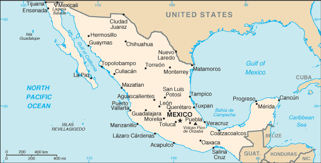
 Mexico
Mittelamerika
Ort: Middle America, bordering the Caribbean Sea and the Gulf of Mexico, between Belize and the US and bordering the North Pacific Ocean, between Guatemala and the US
Geografische Koordinaten: 23° 0' N, 102° 0' W
Küste km: 9,330 km km
Klima: varies from tropical to desert
Gelände: high, rugged mountains; low coastal plains; high plateaus; desert
Höhe: lowest point: Laguna Salada -10 m
highest point: Volcan Pico de Orizaba 5,700 m
Natürliche Gefahren: tsunamis along the Pacific coast, volcanoes and destructive earthquakes in the center and south, and hurricanes on the Pacific, Gulf of Mexico, and Caribbean coasts
Währung: Mexican peso (MXN)
Bevölkerung: 106,202,903 (July 2005 est.)
Sprachen: Spanish, various Mayan, Nahuatl, and other regional indigenous languages
Hauptstadt: Mexico
Bereiche: 31 states and 1 federal district* ; Aguascalientes, Baja California, Baja California Sur, Campeche, Chiapas, Chihuahua, Coahuila de Zaragoza, Colima, Distrito Federal*, Durango, Guanajuato, Guerrero, Hidalgo, Jalisco, Mexico, Michoacan de Ocampo, Morelos, Nayarit, Nuevo Leon, Oaxaca, Puebla, Queretaro de Arteaga, Quintana Roo, San Luis Potosi, Sinaloa, Sonora, Tabasco, Tamaulipas, Tlaxcala, Veracruz-Llave, Yucatan, Zacatecas
Mehr Details
| Jan | Feb | Mar | Apr | May | Jun | Jul | Aug | Sep | Oct | Nov | Dec | |
|---|---|---|---|---|---|---|---|---|---|---|---|---|
| Climate | ||||||||||||
| Air temp. | ||||||||||||
| Water temp. | ||||||||||||
| Equipment | ||||||||||||
| Best season | ||||||||||||
Zusätzliche Karte
Möchtest du Informationen über Mexico hinzufügen? Lass es uns wissen ...
Dies ist eine interaktive Karte! Verwende die Steuerelemente zum schwenken und zoomen.
- Tauch logs (472)
- ausflüge (33)
- Fotos (507)
- Videos (14)
- Teile
- Favorit
-
Deine Favoriten und zukünftigen Tauchplatzlisten
Deine bevorzugte Zone ist nicht aufgeführt? Neue Zone hinzufügen
Zonen
| Zonen (9) | Tauchplätze | Sub Zonen |
|---|---|---|
| Baja California | 48 | 5 |
| Capital Region | 2 | 1 |
| Central Highlands | 2 | 0 |
| Central Pacific | 24 | 3 |
| Islas Revillagigedos | 6 | 0 |
| Northeast - Monterrey | 1 | 0 |
| Northwest - Sinaloa & Sonora | 35 | 3 |
| Southern Gulf of Mexico | 10 | 1 |
| Yucatán Peninsula | 123 | 9 |


 Tauchlogs
|
Tauchtrips
|
Kommentare
Von schris , 11-04-2018
Use wannadive zone download link - There are only two dive site for now in this area; you can download them from https://www.wannadive.net/spot/Central_America/Mexico/Baja_California/La_Paz___Isla_Partida/ See the download link and click on the available output format.
Von dfb72es , 10-04-2018
COORDENADAS GPS - HOLA A TODOS, ESTOY EN LA BÚSQUEDA DE COORDENADAS GPS DE TODO LO QUE ESTE SUMERGIDO EN LA ZONA DE LA PAZ BCS MX.
GRACIAS
Errors, Feedback
Wenn du neue Information hinzufügen möchtest, oder Fehler in diesem Land gefunden hast, Schicken Sie uns Ihr Feedback.
Bewerbe
Wannadive.net 24/24
Wannadive.net auf deinem Handy
![]()
RSS Alle RSS-Feeds von Wannadive.net
Newsletter Alle News per Email