Passwort verloren? Neuer Benutzer? Registrieren
Big eye, Philippines. Photo by Stephane Rochon.
Genieße und Trage etwas bei!
| Finde den besten Tauchplatz |
|
|
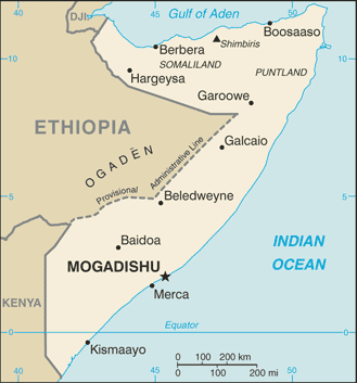
 Somalia
Afrika
It is NOT recommanded to organize a dive trip in Somalia now. A civil war started in 2006 and it is dangerous to go there for now.
Ort: Eastern Africa, bordering the Gulf of Aden and the Indian Ocean, east of Ethiopia
Geografische Koordinaten: 10° 0' N, 49° 0' E
Küste km: 3,025 km km
Klima: principally desert; northeast monsoon (December to February), moderate temperatures in north and very hot in south; southwest monsoon (May to October), torrid in the north and hot in the south, irregular rainfall, hot and humid periods (tangambili) between monsoons
Gelände: mostly flat to undulating plateau rising to hills in north
Höhe: lowest point: Indian Ocean 0 m
highest point: Shimbiris 2,416 m
Natürliche Gefahren: recurring droughts; frequent dust storms over eastern plains in summer; floods during rainy season
Währung: Somali shilling (SOS)
Bevölkerung: 8,863,338 (July 2006 est.)
Sprachen: Somali (official), Arabic, Italian, English
Hauptstadt: Mogadishu
Bereiche: 18 regions: Awdal, Bakool, Banaadir, Bari, Bay, Galguduud, Gedo, Hiiraan, Jubbada Dhexe, Jubbada Hoose, Mudug, Nugaal, Sanaag, Shabeellaha Dhexe, Shabeellaha Hoose, Sool, Togdheer, Woqooyi Galbeed
Mehr Details
| Jan | Feb | Mar | Apr | May | Jun | Jul | Aug | Sep | Oct | Nov | Dec | |
|---|---|---|---|---|---|---|---|---|---|---|---|---|
| Climate | ||||||||||||
| Air temp. | ||||||||||||
| Water temp. | ||||||||||||
| Equipment | Nie wiem | Nie wiem | Nie wiem | Nie wiem | Nie wiem | Nie wiem | Nie wiem | Nie wiem | Nie wiem | Nie wiem | Nie wiem | Nie wiem |
| Best season | ||||||||||||
Zusätzliche Karte
Möchtest du Informationen über Somalia hinzufügen? Lass es uns wissen ...
Dies ist eine interaktive Karte! Verwende die Steuerelemente zum schwenken und zoomen.
- Tauch logs (0)
- ausflüge (0)
- Fotos (0)
- Videos (0)
- Teile
- Favorit
-
Deine Favoriten und zukünftigen Tauchplatzlisten
Deine bevorzugte Zone ist nicht aufgeführt? Neue Zone hinzufügen
Zonen
| Zonen (1) | Tauchplätze | Sub Zonen |
|---|---|---|
| Bajuni Islands | 1 | 0 |
 Kommentare
Sei der erste der einen Kommentar über dieses Land schreibt
Errors, Feedback
Wenn du neue Information hinzufügen möchtest, oder Fehler in diesem Land gefunden hast, Schicken Sie uns Ihr Feedback.
Bewerbe
Wannadive.net 24/24
Wannadive.net auf deinem Handy
![]()
RSS Alle RSS-Feeds von Wannadive.net
Newsletter Alle News per Email