Dies ist eine interaktive Karte! Verwende die Steuerelemente zum schwenken und zoomen.
Zugang
|
English (Übersetze diesen text in Deutsch): Out the Hwy #333 that makes the Peggy's Cove loop, on the east side of St. Margaret's Bay is Indian Point. It is a long narrow point with the "Indian Point Road" running its length. Watch for the road sign on the right and the road makes a loop so you can't get lost!
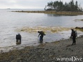
The dive site is on the inside or east tip of the point. Indian Point has two island off its tip - the first is connected by a berm sheltering the dive site. One can dive on the sheltered inside or hike across to the open bay side.
The dive is quite shallow, so high tide is recommended for this spot. It is very easy with good parking along the edge of the road and a nice easy "driveway" like slope to walk down on.
English (Übersetze diesen text in Deutsch): Out the Hwy #333 that makes the Peggy's Cove loop, on the east side of St. Margaret's Bay is Indian Point. It is a long narrow point with the "Indian Point Road" running its length. Watch for the road sign on the right and the road makes a loop so you can't get lost!
The dive site is on the inside or east tip of the point. Indian Point has two island off its tip - the first is connected by a berm sheltering the dive site. One can dive on the sheltered inside or hike across to the open bay side.
The dive is quite shallow, so high tide is recommended for this spot. It is very easy with good parking along the edge of the road and a nice easy "driveway" like slope to walk down on.
Out the Hwy #333 that makes the Peggy's Cove loop, on the east side of St. Margaret's Bay is Indian Point. It is a long narrow point with the "Indian Point Road" running its length. Watch for the road sign on the right and the road makes a loop so you can't get lost!
The dive site is on the inside or east tip of the point. Indian Point has two island off its tip - the first is connected by a berm sheltering the dive site. One can dive on the sheltered inside or hike across to the open bay side.
The dive is quite shallow, so high tide is recommended for this spot. It is very easy with good parking along the edge of the road and a nice easy "driveway" like slope to walk down on.
English (Übersetze diesen text in Deutsch): Out the Hwy #333 that makes the Peggy's Cove loop, on the east side of St. Margaret's Bay is Indian Point. It is a long narrow point with the "Indian Point Road" running its length. Watch for the road sign on the right and the road makes a loop so you can't get lost!
The dive site is on the inside or east tip of the point. Indian Point has two island off its tip - the first is connected by a berm sheltering the dive site. One can dive on the sheltered inside or hike across to the open bay side.
The dive is quite shallow, so high tide is recommended for this spot. It is very easy with good parking along the edge of the road and a nice easy "driveway" like slope to walk down on.
Wie? Vom Ufer
Entfernung Sofortiger Zugang
Leicht zu finden? Leicht zu finden
|
|
Tauchplatz Merkmale
Durchschnittstiefe 5 m / 16.4 ft
max. Tiefe 9 m / 29.5 ft
Strömung Keine
Sichtweite Mittel ( 5 - 10 m)
Qualität
Tauchplatz Qualität Gut
Erfahrung Alle Taucher
Biointeresse Interessant
Mehr Details
Wochenaufkommen
Wochenendaufkommen
Art des Tauchgangs
- Ambiente
Tauchplatz Aktivitäten
- Meeresbiologie
- Kinder tauchen
- Nachttauchen
- Erster Tauchgang
- Tauchtraining
- Schnorcheln / Freitauchen
- Orientierung
- Photography
Gefahren
Zusätzliche Informationen
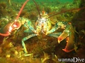
English (Übersetze diesen text in Deutsch): Since the site is shalllow, a little extra wight is recommended. It is good for macrophotography with lots of fish, crabs, lobsters and other subjects to shoot.
This is an easy, basic dive spot and good when others are too rough as it is very protected from east, west and north winds.
Since the site is shalllow, a little extra wight is recommended. It is good for macrophotography with lots of fish, crabs, lobsters and other subjects to shoot.
This is an easy, basic dive spot and good when others are too rough as it is very protected from east, west and north winds.
English (Übersetze diesen text in Deutsch): Since the site is shalllow, a little extra wight is recommended. It is good for macrophotography with lots of fish, crabs, lobsters and other subjects to shoot.
This is an easy, basic dive spot and good when others are too rough as it is very protected from east, west and north winds.
 Kommentare
Zeige alle (0)...
Sei der erste der einen Kommentar über dieses Land schreibt
Errors, Feedback
Du kannst diese Seite ändern um Fehler zu beheben oder neue Information hinzuzufügen. Wenn du Probleme mit der Seite hast, Schicken Sie uns Ihr Feedback.
Wannadive.net 24/24
Wannadive.net auf deinem Handy

Newsletter Alle News per Email
 Indian Point